This online platform provides maps of nitrogen dioxide (NO2)
concentrations over Finnish cities. The maps are based on annual
averages of the tropospheric NO2 retrievals obtained by the
Copernicus TROPOMI/Sentinel-5P satellite instrument. NO2 is an
air pollutant mainly generated by combustion processes from
anthropogenic pollution sources (including transportation,
energy production and other industrial activities).
Concentrations of short-lived gases like NO2 can be used as
proxies of NO2 emissions when averaged in time and space, since
averaging removes some of the short-term variability due to
changing meteorological conditions.
The service is part of the Health showcase of the EU 2020
e-shape project (Pilot 2.3 EO-based pollution-health risks
profiling in the urban environment). The service maintenance and
the data analysis are carried on at the Space and Earth
Observation Centre at the Finnish Meteorological Institute. The
retrieval of the TROPOMI NO2 product was developed at KNMI and
the data are distributed via the ESA Sentinel hub. Further
information about the service and the data used can be found
here
or you can
contact the responsible investigator Iolanda Ialongo, FMI.
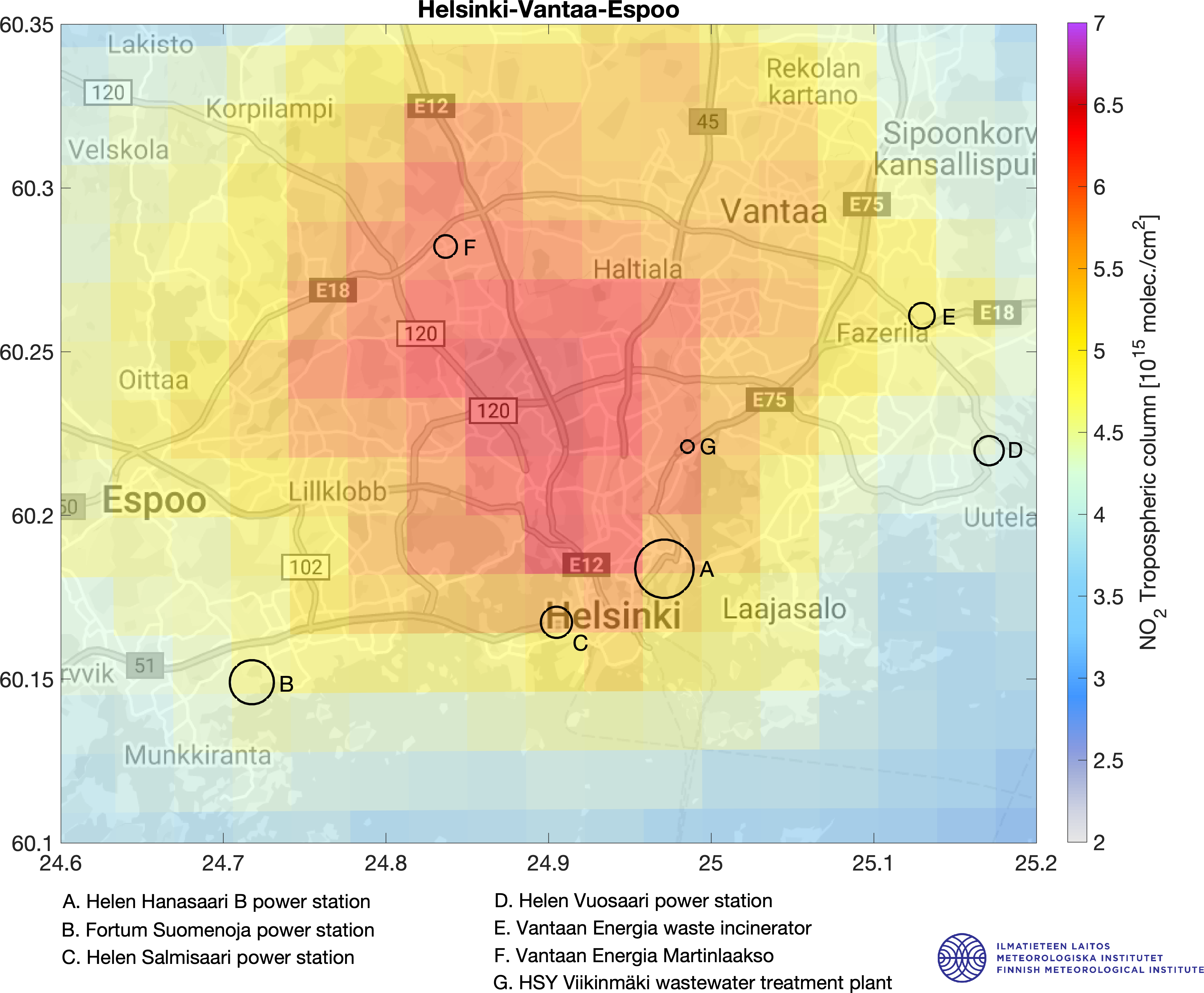
The maps show the average of the satellite-based NO2
tropospheric columns retrieved from TROPOMI (TROPOspheric
Monitoring Instrument) over the period 1.4.-30.9.2019. The data
have been gridded at 2 km spatial resolution using oversampling
(i.e., gridding smaller than the original TROPOMI pixel size;
Sun et al. 2018). In order to enhance the NO2 signal close to
the emission sources, only TROPOMI data corresponding to calm
wind conditions (wind speed smaller than 3 m/s) have been
included in the maps. TROPOMI is the only instrument onboard the
ESA’s Sentinel 5 Precursor (S5P) satellite and it is part of the
EU Copernicus Earth Observation program (Veefkind et al., 2012).
Van Geffen et al. (2019) have described in detail the TROPOMI
NO2 retrieval algorithm. TROPOMI/S5P data are openly available
via the
ESA Sentinel hub. TROPOMI NO2 products are routinely validated against
ground-based reference measurements at global level and in
Finland in particular (Ialongo et al., 2020).
The black circles in the maps indicate the known stationary NO2
emission sources from the
E-PRTR database. The size of the circle is proportional to the 2017 annual
emissions. The rest of the emissions come from the
transportation sector (road and shipping). Note also that the
NO2 maps over different Finnish cities have different colorscale
ranges, so the colors cannot be directly compared from one map
to the other. The NO2 map over Finland is shown
here.
Nitrogen dioxide (NO2) is a polluting gas produced from fossil
fuel combustion processes, i.e. from transportation, energy
production and industrial processes. NO2 participates to the
formation of tropospheric ozone and nitrate aerosols and has
negative effects on human health and the environment. NO2 is a
short-lived gas and therefore can be found in high
concentrations close to the emission sources. It is worth noting
that NO2 columns observed from space are not the same as NO2
emissions because the NO2 column amount in the atmosphere
depends on the local emissions, chemistry and transport.
Nevertheless, NO2 columns can be used as a proxy of NO2
emissions if averaged in time and space, as done in these
website maps.
Note also that satellite instruments measure the NO2
concentrations as molecules per unit area in the atmospheric
column from the Earth surface to the tropopause (unit of
molec./cm2). On the other hand, traditional air
quality stations measure NO2 concentrations at the surface (unit
of microg/m3), which is a different quantity and
cannot be directly compared to satellite observations.
Also, TROPOMI observations are only available 2-3 times a day
over Finland, around 11-15 local time. The S5P satellite
overpass time typically corresponds to the NO2 daily local
minimum between the morning and afternoon peaks due to commuter
traffic, while in situ air quality measurements are available at
high temporal resolution throughout the day. In addition, since
satellite-based NO2 retrievals are based on the solar light
reflected from the earth’s surface and atmosphere back to the
satellite, TROPOMI NO2 retrievals are not available during the
night, during winter at high latitudes or under cloudy
conditions. On the other hand, satellite retrievals have daily
global coverage and can complement traditional air quality
information where the latter are not available.
Ialongo, I., Virta, H., Eskes, H., Hovila, J., and Douros, J.:
Comparison of TROPOMI/Sentinel-5 Precursor NO2 observations with
ground-based measurements in Helsinki, Atmos. Meas. Tech., 13,
205–218,
https://doi.org/10.5194/amt-13-205-2020, 2020.
Sun, K., Zhu, L., Cady-Pereira, K., Chan Miller, C., Chance, K.,
Clarisse, L., Coheur, P.-F., González Abad, G., Huang, G., Liu,
X., Van Damme, M., Yang, K., and Zondlo, M.: A physics-based
approach to oversample multi-satellite, multispecies
observations to a common grid, Atmos. Meas. Tech., 11,
6679–6701,
https://doi.org/10.5194/amt-11-6679-2018, 2018.
van Geffen, J. H. G. M., Eskes, H. J., Boersma, K. F.,
Maasakkers, J. D., and Veefkind, J. P.: TROPOMI ATBD of the
total and tropospheric NO2data products, Tech. Rep.
S5P-KNMI-L2-0005-RP, Koninklijk Nederlands Meteorologisch
Instituut (KNMI), CI-7430-ATBD, issue 1.4.0, available at:
https://sentinels.copernicus.eu/documents/247904/2476257/Sentinel-5P-TROPOMI-ATBD-NO2-data-products
(last access: 20 July 2020), 2019.
Veefkind, J. P., Aben, I., McMullan, K., Forster, H., de Vries,
J., Otter, G., Claas, J., Eskes, H. J., de Haan, J. F.,
Kleipool, Q., van Weele, M., Hasekamp, O., Hoogeveen, R.,
Landgraf, J., Snel, R., Tol, P., Ingmann, P., Voors, R.,
Kruizinga, B., Vink, R., Visser, H., and Levelt, P. F.: TROPOMI
on the ESA Sentinel-5 Precursor: A GMES mission for global
observations of the atmospheric composition for climate, air
quality and ozone layer applications, Remote Sens. Environ.,
120, 70–83,
https://doi.org/10.1016/j.rse.2011.09.027, 2012.
Iolanda Ialongo, PhD
Henrik Virta
Finnish Meteorological Institute Space and Earth Observation
Centre
Erik Palménin aukio 1
00560 Helsinki (Finland)
email: name.surname@fmi.fi